Marken: Unterschied zwischen den Versionen
Axel (Diskussion | Beiträge) +Kartenlinks |
Axel (Diskussion | Beiträge) fmt Karte; |
||
| Zeile 14: | Zeile 14: | ||
{{ | {{ | ||
#display_map: | #display_map: | ||
52. | 52.472505239937,5.1055297855055 ~ ~ Ankerplatz östlich vom Bukdijk ~ Symbol INT Anchorage Area blue 32px.png; | ||
52.471422095775,5.0960140230018 ~ ~ Ankerplatz westlich vom Bukdijk ~ Symbol INT Anchorage Area blue 32px.png; | 52.471422095775,5.0960140230018 ~ ~ Ankerplatz westlich vom Bukdijk ~ Symbol INT Anchorage Area blue 32px.png; | ||
52.458211774691,5.1005308629827 ~ ~ Hafen ~ Symbol INT Harbour 32px blue.png; | 52.458211774691,5.1005308629827 ~ ~ Hafen ~ Symbol INT Harbour 32px blue.png; | ||
52.456106646851,5.1052998306113 ~ ~ Supermarkt ~ Symbol POI blue-yellow.png; | 52.456106646851,5.1052998306113 ~ ~ Supermarkt ~ Symbol POI blue-yellow.png; | ||
52.459787285886,5.1391385795431 ~ ~ Leuchtturm ~ Symbol POI blue-yellow.png; | 52.459787285886,5.1391385795431 ~ ~ Leuchtturm ~ Symbol POI blue-yellow.png; | ||
| centre=52. | | centre=52.467799510891,5.1007232669508 | ||
| height=550px | | height=550px | ||
| width=50% | | width=50% | ||
| resizable=yes | | resizable=yes | ||
| zoom= | | zoom=13 | ||
| service=openlayers | | service=openlayers | ||
| layers=osm-mapnik, osm-oseam, osm-oseam-cemt | | layers=osm-mapnik, osm-oseam, osm-oseam-cemt | ||
Version vom 6. Juni 2021, 17:09 Uhr
| Navigation | |
|---|---|
| Seegebiet | Binnen> Markermeer |
| Politisch | Europa > Niederlande |
Koordinaten: 52° 27.76'N 005° 06.32'E
Marken ist eine kleine Insel auf der Westseite des Markermeer, den Ortschaften Monnickendam und Volendam vorgelagert. Seit 1957 ist die Insel über einen Damm mit dem Festland verbunden.
Der Ort auf der Westseite der Insel besteht aus wenigen einfachen Häusern um das Hafenbecken herum, einem Stadtkern mit Kirche und Museum und einigen kleinen schönen Gassen nordöstlich des Hafens. Außerdem gibt es ein kleines ansprechendes Hotel. Direkt am Hafen findet man mehrere Gaststätten, wo man im Sommer auch draußen sitzen und das Hafenleben beobachten kann.
Weniger als einen halben Kilometer vom hafen, in der Nähe der Landstraße unweit des Parkplatzes für Besucher (nur Einheimische dürfen im Ort ihr Auto parken) findet man einen gut sortierten Supermarkt. In der Saison ist an diesem Parkplatz auch ein Fahrradverleih.
Für einen Spaziergang kann man den Leuchtturm auf der Ostseite der Insel als Ziel nutzen. Wegen seiner charakteristischen Form Paard van Marken genannt, dient er nautisch als optische Ansteuerungsmarke auf dem Weg von Enkhuizen nach Amsterdam.
Aufgrund der Nähe zu Amsterdam - es gibt eine direkte Busverbindung, welche bis in die Nacht bedient wird - und wegen der Fahrgastschiffverbindung von Volendam ist gerade am Wochenende und im Sommer mit vielen Besuchern zu rechnen. Marken selbst hat nur etwa 1.800 Einwohner. Die Zahl der Touristen erreicht eine Million pro Jahr.
Wenn aber der letzte Touristenbus die Insel über den Deich verlassen und die letzte Fähre gegen 18 Uhr nach Volendam aufgebrochen und den Großteil der Besucher mitgenommen hat, dann wird es im Hafen ruhig und man spürt den Charme des alten Fischerdorfes.
Maßstab in Landmeilen (statute miles) beziehungsweise Fuß und in metrischen Maßen.
Liege- und Ankerplätze
Hafen
Der Hafen von Marken liegt geschützt auf der Westseite der Insel. Die Einfahrt zur Gouwzee zwischen Marken und dem Festland - die gleiche wie für Volendam oder Monnikendam - ist nur von Norden kommend möglich, sie ist gut betonnt. Am südlichen Ende des Fahrwassers gut zwei Meilen südlich der Einfahrt nach Volendam liegt der Hafen östlich direkt gegenüber Monikendam. Einige Liegeplätze befinden sich nach Einfahrt in das Hafenbecken an Steuerbord gegenüber der Anlegestege für die Fahrgastschiffe; also sollte man bei Ablegen auf deren Manöver achten. Ansonsten ist der freundliche Hafenmeister meist schnell zur Stelle und weist eine passende Box zu.
Obwohl der Hafen von Marken relativ klein ist, gibt es hier drei unterschiedliche Verwalter von Liegeplätzen. Die Liegeplätze nach der Einfahrt direkt an Steuerbord gehören der Segelvereinigung "Het Y", welche auch in Enkhuizen und Durgerdam über ein Kontingent an vereinseigenen Liegeplätzen verfügt. Die Liegeplätze in der zweiten Gasse an Steuerbord und die Boxen an Backbord gehören dem Wassersportverein Marken. Alle genannten Liegeplätze verfügen über Strom an der Box und Wasser am Steiger. Die Hafenmeister beider Vereine kassieren die Liegegebühren direkt am Steg. Ein grünes Schild an der Box signalisiert, dass diese für einen Gast frei ist. Man sucht sich selbst die Box aus.
Darüber hinaus kann man auch an Backbord voraus an der Hafenmauer anlegen - in der Saison allerdings häufig nur im Päckchen. Diese Liegeplätze haben KEINEN Stromanschluss und werden von der Gemeinde Marken verwaltet. Deren Hafenmeister hat ein eigenes Haus in der Nordostecke des Hafens.
Die Sanitäranlagen des Hafens sind insgesamt eher bescheiden. Tagsüber muss man sich die Toiletten mit den zahlreichen Touristen teilen. Ein eigenes WC an Bord ist deshalb empfehlenswert. Der Duschbereich ist nur über eine Zahlenkombination zugänglich. Nicht vergessen, diese beim Hafenmeister zu erfragen!
Schiffe mit größerem Tiefgang sollten beim Ansteuern/Anlegen in Boxen am Südende des Hafens ihren Tiefenmesser im Auge behalten. Die häufig ein- und ausfahrenden Fahrgastschiffe wirbeln den Grund auf, der sich dann bevorzugt in dieser Ecke des Hafens absetzt. Zudem ist es so, dass sich bei kräftigen längeren Winden aus Süd der Wasserspiegel der nach Süden durch den Deich abgeschlossenen Gouwzee und damit auch des Hafens verringern kann.
Ankerplätze
Westlich und östlich des nach Norden führenen Bukdijks (ein nach Aufgabe eines Polderprojekts nicht vollendeter Deich) kann man je nach Wetterlage ankern. Wassertiefen um die 1,50 Meter.
Bilder
-
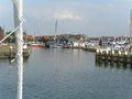 Einfahrt nach Marken

IJsselmeer: Andijk | Breezanddijk | De Kreupel | Den Oever | Enkhuizen | Enkhuizen (Naviduct) | Hindeloopen | Lelystad | Lelystad (Houtribsluizen) | Kornwerderzand | Lemmer | Makkum | Medemblik | Oosterdijk | Oude Zeug | Stavoren | Trintelhaven | Urk | Workum
Markermeer: Broekerhaven | Edam | Enkhuizen (Naviduct) | Hoorn | Lelystad | Lelystad (Houtribsluizen) | Marken | Marker Wadden | Monnikendam | Oostvaardersdiep | Oostvaardersdijk | Uitdam | Volendam | Wijdenes
Randmeren (von SW nach NE): IJmeer | Gooimeer | Eemmeer | Velouwerandmeren (mit Nuldernauw |Wolderwijd |Veluwemeer |Drontermeer) | Randmeren Noord (mit Vossemeer | Ketelmeer mit IJsseloog | Ramsdiep | Zwarte Meer)