Calvi: Unterschied zwischen den Versionen
Peter (Diskussion | Beiträge) K Textersetzung - „<googlemap“ durch „Vorlage:TODO-Maps<googlemap“ |
K map geändert |
||
| Zeile 1: | Zeile 1: | ||
{{Navigation|Seegebiet = [[Mittelmeer]]|Politisch = [[Europa]] > [[Frankreich]] > [[Korsika]]}} | {{Navigation|Seegebiet = [[Mittelmeer]]|Politisch = [[Europa]] > [[Frankreich]] > [[Korsika]]}} | ||
{{ | {{#display_map: | ||
42.552905, 8.736671 | 42.552905, 8.736671~ ~ ~ ~ ~Notre Dame de la Serra; | ||
42.584114, 8.725907 | 42.584114, 8.725907~ ~ ~ ~ ~Punta Revellata; | ||
42.572548, 8.729941 | 42.572548, 8.729941~ ~ ~ ~ ~Ankern; | ||
42.56343, 8.765608 | 42.56343, 8.765608~ ~ ~ ~ ~Bojenfeld; | ||
42.537632, 8.792559 | 42.537632, 8.792559~ ~ ~ ~ ~Flughafen; | ||
|centre=42.567242,8.781509 | |||
|zoom=12 | |||
|width=400 | |||
|height=400 | |||
|type=physical | |||
}} | |||
{{TOCright}} | {{TOCright}} | ||
Version vom 8. November 2013, 11:57 Uhr
| Navigation | |
|---|---|
| Seegebiet | Mittelmeer |
| Politisch | Europa > Frankreich > Korsika |
Die Stadt im Nordwesten Korsikas ist meist der erste Hafen für alle Skipper, die aus Südfrankreich die Insel anlaufen.
Hafen
Calvi verfügt über einen bei Libeccio gut geschützten Yachthafen mit eine Tankstelle und guten sanitären Einrichtungen. Im Sommer ist der Hafen in der Regel überfüllt. (??-Anfang September 2012 waren ausreichend Plätze vorhanden - die Krise hat auch hier zugeschlagen!) Die Anmeldung über VHF 9 ist erwünscht, man wird (meist) von einem Schlauchboot empfangen und eingewiesen (Mooringleine vorne, Heck zum Kai). Preise: 70,00 Euro/Nacht und 13,4m Länge im September 2012.
Es ist jedoch ein - kostenpflichtiges (teuer) - Bojenfeld in einiger Entfernung (Tank des Aussenborders kontrollieren/Paddel mitnehmen!) vor dem Hafen eingerichtet worden. Die Yachten im Bojenfeld liegen bei Libeccio allerdings nicht unbedingt sehr ruhig. Auch ist der Transfer mit dem Dinghi dann kein Vergnügen, wenn überhaupt möglich. Normalerweise ist ein Schlauchboot zum Empfang bereit, sonst Kanal 8 oder 04 95.65.42.22.
Falls der Hafen bei Libeccio überfüllt ist, am besten vor Cala d'Alga ankern.
Ankerplätze
In der Bucht von von Calvi selbst ist das Ankern verboten. Zwischen der Halbinsel mit der Zitadelle und der Punta Revellata (also südlich des Leuchtturms) gibt es jedoch reichlich Gelegenheit dazu. Mit einem guten Dinghi kann man bei ruhigem Wetter auch hinüber nach Calvi fahren.
Sehenswürdigkeiten
Zitadelle oberhalb des Hafens
Chapelle Notre Dame de la Serra
Schon vom Hafen aus sieht man beim Blick nach Süden die kleine Kapelle auf dem Berg stehen. Es gibt einen sehr schönen, markierten Wanderweg von der Stadt zur Kapelle (geschätzt 5 km, 200 Höhenmeter). Der Weg ist steinig, gutes Schuhwerk von Vorteil. Um den Weg zu finden, lohnt es sich, im Tourismusbüro (gleich "neben" der Capitainerie) zu fragen. Von der Kapelle aus hat man einen atemberaubenden Blick über die Bucht von Calvi und nach Osten bis zum Monte Cintú.
Bilder
-
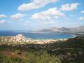 Bucht von Calvi, von der N.D. de la Serra aus
 -
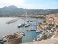 Hafen von Calvi

