Spetsai: Unterschied zwischen den Versionen
→O. Baltizas: erw Beschreibung |
Axel (Diskussion | Beiträge) K fmt, check coords |
||
| Zeile 1: | Zeile 1: | ||
{{Navigation|Seegebiet=[[Mittelmeer]] > [[Ägäis]] > [[Peloponnes]] > [[Argolischer Golf]]|Politisch=[[Europa]] > [[Griechenland]]}} | {{Navigation|Seegebiet=[[Mittelmeer]] > [[Ägäis]] > [[Peloponnes]] > [[Argolischer Golf]]|Politisch=[[Europa]] > [[Griechenland]]}} | ||
{{Koordinate|U|37_15.800_N_023_09.900_E| | {{Koordinate|U|37_15.800_N_023_09.900_E|37° 15,80' N 023° 09,90' E|Spetsai}} | ||
[[Bild:Spetsai_Sat.jpg|thumb|Ns.Spetsai]] | [[Bild:Spetsai_Sat.jpg|thumb|Ns.Spetsai]] | ||
| Zeile 65: | Zeile 65: | ||
[[Category:Peloponnes]] | [[Category:Peloponnes]] | ||
[[Category:Argolischer Golf]] | [[Category:Argolischer Golf]] | ||
[[Category:Hafen]] | |||
[[Category:Ankerplatz]] | |||
Version vom 23. Januar 2010, 01:38 Uhr
| Navigation | |
|---|---|
| Seegebiet | Mittelmeer > Ägäis > Peloponnes > Argolischer Golf |
| Politisch | Europa > Griechenland |
Koordinaten: 37° 15,80' N 023° 09,90' E

Die Insel Ns. Spetsai (auch: Spetses) liegt im Nordosten des Argolischen Golfes, südwestlich der Insel Dokos, gegenüber der Einfahrt nach Porto Kheli. Die Insel ist 22 km² groß, stellenweise bewaldet, die höchste Erhebung ist 274 m hoch.
Die Besiedlungsgeschichte reicht mehr als 5000 Jahre zurück. Auf die jüngere Geschichte sind die Einwohner allerdings besonders stolz, war Spetsai doch die erste Insel, die sich 1821 dem Aufstand gegen die Türken anschloß.
Die Insel ist ein Touristenzentrum.
Entfernungen
| Von | Nach | Entfernung (ca) | Richtung |
|---|---|---|---|
| Spetses | Lavrion | 57 sm | NE |
| Spetses | Athen | 58 sm | NNE |
| Spetses | Milos | 65 sm | SE |
| Spetses | Ak. Maleas | 49 sm | S |
Liege- und Ankerplätze
O. Baltizas
Der Fährhafen von Spetsai befindet sich östlich einer kurzen Mole in einer flachen Bucht und ist ausschließlich dem Fährverkehr vorbehalten. Yachten liegen in der etwas östlich noch im Stadgebiet, unmittelbar beim Ak. Fanari gelegenen O. Baltizas. Der gesamte Ostteil der Bucht ist befestigt, der Westteil nördlich der Mole Steilufer.
Hier kann man entweder
- an der unmittelbar im Einfahrtsbereich im Westen liegenden, kurzen Mole auf 3 - 4 m vor Buganker anlegen, oder
- im engen Südteil, an der westlichen Pier auf 3 m vor Buganker anlegen, oder
- am Südende des breiten Teils, westlich vom Slip vor einer Taverne ankern (eventuell mit sehr langen Landleinen).
Der Ankergrund ist Sand bzw. Schlick und hält ausreichend.
Der Hafen ist in den Sommermonaten sehr stark frequentiert, trotzdem findet man immer noch einen Platz.
Die Versorgungsmöglichkeiten sind auf Grund der touristischen Infrastruktur gut. Es gibt mehrere Supermärkte und Läden, eine Werft und eine Tankstelle, einige Tavernen und Bars. Treibstoff ist per Tankwagen von der Tankstelle unweit der Werft erhältlich, Wasser kann man dort auch beziehen.
Die Insel ist unter anderem bekannt für ihren traditionellen Bootsbau. So kann man bei den Werften am Ostufer des inneren Hafens Kaïkis in allen Größen und Bauphasen beobachten.
Ankerbuchten
Sowohl am Südende, beim Ak. Zastano, als auch im Norden beim Ak. Vaiza gibt es schöne Ankerbuchten, sich sich je nach Wetter- und Windlage vor allem für einen Tagesaufenthalt als Badebuchten eignen. Beide Buchten sind in der Saison gut frequentiert. In der Südbucht gibt es eine, in der Nordbucht mehrere Tavernen.
Hinweise
- In dieser Gegend gibt es häufig Südwind aus einer Gegenbewegung zum Meltemi. Dann setzt im Steno Spetsai, also in der Durchfahrt zwischen Spetses und dem Festland ausgeprägter Strom, der insbesondere beim befeuerten Ak. Aimilianos auflandig ist.
- Südlich der Insel liegt ein U-Boot Übungsgebiet.
- Östlich von Spetsai und der vorgelagerten Insel Ns. Spetsopoula gibt es einige Untiefen und überspülte Felsen.
[Stand Juli 2006]
Bilder
-
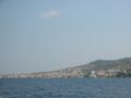 Spetsai aus dem Steno Spetsai

Seegebiete: Argolischer Golf und Ostküste | Golf von Hydra | Lakonischer Golf | Messenischer Golf | Peloponnes (Westküste) | Golf von Patras | Golf von Korinth
Häfen und Liegeplätze: Ns. Dokos | Dyros | Ns. Elafonisos | Gerakas | Gythion | Ns. Hydra | Leonidi | Limeni | Kagio | Kapari | Katakolon | Korakonisia | Kilada | Kyllini | Kyparissi | Kyparissia | Ns. Kythira |
Monemvasia | Nafplion | Phokianos | Plitra | Porto Kheli | Poulithra | Romvi | Ns. Spetsai | Ns. Trizonia